| Shotover - The Origin of the Name |
 It has been seriously suggested that "Shotover" is a corruption of the Norman
French "Chateau Vert" because a green hunting lodge once stood on the hill. This is
nonsense. There is no evidence of there ever having been such a green building
on Shotover and in any case the name Shotover predates the Norman conquest.
It has been seriously suggested that "Shotover" is a corruption of the Norman
French "Chateau Vert" because a green hunting lodge once stood on the hill. This is
nonsense. There is no evidence of there ever having been such a green building
on Shotover and in any case the name Shotover predates the Norman conquest.
 Another popular suggestion is that the name commemorates the efforts of an archer
who was able to shoot his arrow clear over the top of the hill.
The best horizontal range that might be achieved from a longbow is around
300 to 350 metres. If we ignore the foothills and assume a shot across the
narrowest part of the hill, from The Ridings to a similar point on the opposite
side of the hill, the linear distance covered is around 1.25km, before any extra
effort is assumed to clear the summit. So here is another explanation that can
be completely ruled out.
Another popular suggestion is that the name commemorates the efforts of an archer
who was able to shoot his arrow clear over the top of the hill.
The best horizontal range that might be achieved from a longbow is around
300 to 350 metres. If we ignore the foothills and assume a shot across the
narrowest part of the hill, from The Ridings to a similar point on the opposite
side of the hill, the linear distance covered is around 1.25km, before any extra
effort is assumed to clear the summit. So here is another explanation that can
be completely ruled out.
 The most frequently quoted explanation, often said to be the "true explanation" is that
the name derives from the Old English "sceot ofer" meaning "steep hill". I
have to confess that seeing this often in print, I was for some time, prepared to
believe it. Doubts crept in when I took the trouble to look up the words "sceot"
and "ofer" in available on-line dictionaries of Old English.
Here one finds that "sceot" (or more usually "scot") translates as "shot". Whilst
"ofer" translates as "over" or "above". So far from "sceot ofer" meaning
"steep hill", it actually means "shot over" and we are back where we started!
The most frequently quoted explanation, often said to be the "true explanation" is that
the name derives from the Old English "sceot ofer" meaning "steep hill". I
have to confess that seeing this often in print, I was for some time, prepared to
believe it. Doubts crept in when I took the trouble to look up the words "sceot"
and "ofer" in available on-line dictionaries of Old English.
Here one finds that "sceot" (or more usually "scot") translates as "shot". Whilst
"ofer" translates as "over" or "above". So far from "sceot ofer" meaning
"steep hill", it actually means "shot over" and we are back where we started!
 My belief is that all the above attempts at an explanation stem from a wrong assumption
that "Shotover" describes a hill. Nowadays it is used in this way but historically
a more accurate approach is to think of "Shotover Hill" as being a hill within a much larger
area of land known as "Shotover". There is documentary evidence of this:
My belief is that all the above attempts at an explanation stem from a wrong assumption
that "Shotover" describes a hill. Nowadays it is used in this way but historically
a more accurate approach is to think of "Shotover Hill" as being a hill within a much larger
area of land known as "Shotover". There is documentary evidence of this:
We know the name predates the Norman Conquest. In its Latinised form "Scotorne" it appears as a place description in The Domesday Book (1086). It comes in the section relating to the land held by the king and in translation states: "In Shotover, Stowood, Woodstock, Cornbury and Wychwood are the lordship forests of the King."
Note that at this time "forest" meant an area of land hunted over by the King and subject to "forest law", not necessarily an area covered by trees. Although the term "forest" and the associated forest law as a separate jurisdiction, was only introduced by the Normans, the concept of land used for royal hunts dates back well into the Saxon era.
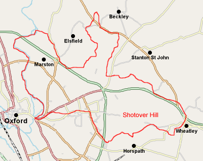
So now we have Shotover as an area of land hunted over by the King and much larger than just the present Shotover Hill. It is known to have stretched all the way down to the river Cherwell, including Headington, St Clements and Marston. The earliest documented evidence of Shotover's extent is to be found in the Boarstall Cartulary Ref 1, which includes a description of a Perambulation of Shotover and Stowood Forest, dating from about 1298. We here show the boundary of Shotover as described in the perambulation, by a red outline, superimposed on a modern map. As you can see, Shotover Hill is a relatively small part of the whole, in the South East corner.
With this in mind, attempts to link the name to specific properties of Shotover Hill make no sense. You need simply think of it as land which was "shot over" by the King and no further explanation is required. Indeed the phrase is still in use, when we refer to people shooting over an estate, the only difference being that nowadays a shotgun has replaced a longbow as the weapon of choice.
| Text copyright © Alan Simpson 2017 | Modern map copyright © OpenStreetMap Contributors 2004-2017 | Back to index. | Last Updated 2017-07-01 |