Miriam Freeborn's Book
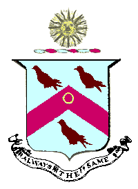
Whilst researching the FREEBORN branch of Helen's family, I came across a fascinating book in the Bodleian Library, entitled "The Demolished Houses of Broad Street and the Freeborn Family". It was written in 1943 and in the Bodleian catalogue is attributed to Emily Sarah Freeborn, one of the last residents of one of the houses. The book itself does not bear an author's name on the title page. However from the text it is clear that it has in fact been written by Miriam Elizabeth Freeborn, Emily's sister in law.The book is a hard-bound, typescript, of around 50 pages, with five original photographs of family members, or their portraits. As a frontispiece the author has included a hand-painted illustration of the Freeborn crest and motto, reproduced here.
Since the pages are original typescript and the paper is too thick to have permitted the production of any carbon copies, it seems reasonable to assume that this is the only copy of the book that ever existed. It is a fascinating document and this web page attempts to cover a small fraction of the information therein, together with some further additions from other sources.
The houses concerned were those at the north eastern corner of Broad Street, which were demolished around 1937 prior to the construction of the new Bodleian library on the site. According to Miriam Freeborn (MEF), the Freeborn house, No.38 had been acquired by the library as early as 1930 in anticipation of the construction of the new building.
As part of her excellent website devoted to Broad Street, Stephanie Jenkins gives a detailed description of these houses and their occupants, on a set of webpages starting here. The rest of the page you are now reading is devoted to Miram Freeborn's recollections and researches relating to the houses.
William Pantin's Study
When the site was being cleared, Dr William Pantin made a detailed record of the medieval and later buildings on the site pioneering the techniques which he later referred to as "Above Ground Archaeology". As part of this work, Miriam was approached by Dr. Pantin (whom she refers to as "Mr.W.A.Pantin") for information about the Freeborn house. This seems to have been the impetus for her own researches into the adjoining houses which resulted ultimately in the production of her own book.Dr. Pantin's work was published in Oxoniensa Vol.II (1937) pp 196/7 and Miriam quotes from relevant sections of this. Whilst she is never overtly critical one senses that she felt Pantin was too eager to accept a romantic story over a prosaic fact. For example, after describing how the Freeborn house had two staircases of equal size and importance, placed back to back, Pantin suggests it was probably due to its having originally been two houses but then goes on to describe a "family legend" concerning a brother and sister who quarrelled but were forced to live together to comply with the terms of an inheritance. Miriam dismisses this with the added footnote. "There is no foundation for the legend! M.E.F."
Dr. Pantin's plans for No.46 Broad Street, together with some photographs of the site, are included in the modern book Oxford, the Buried City by Tom Hassall, published by the Oxford Archaeological Unit in 1987.
A Survey of Oxford in 1772
In addition to her own family knowledge and the work of Dr. Pantin, Miriam quotes from a Survey of Oxford carried out in 1772, as a consequence of the Mileways Act passed in 1771. (This act is often assumed to simply provide for the funding of roads within a mile of the city. However it had a rather wider impact including the destruction of the Northgate and Eastgate and the widening and resurfacing of many roads within the city, including the widening of Magdalen bridge.) The cost of all this work was to be born by a tax on households within the city, based on the length of their street frontage. To assess householders for this tax involved a survey of all properties, including the name of the person responsible to pay the tax (normally the occupier, rather than the landlord), and the length of frontage. This manuscript survived in the hands of the Morrell family and was transcribed in 1911-12 by Rev. H.E.Salter. It was originally published in 1912 then in 1920, republished by the Oxford Historical Society, together with some additional documents, as their Volume 75. Miriam had access to a copy of the original 1912 edition, which had had further notes, added by a Dr. W. Paterson Ellis. It should be noted that there was no house numbering at the time of the original survey. In his transcript, Rev. Salter has attempted to correlate the descriptions with the "modern" house numbers, based on the frontage measurements given.
The Houses which were Demolished
The plan which follows shows the houses concerned, as they appeared at the end of the 19th century. It is based on a 1900 Ordnance Survey map, incorporating revisions to 1898. The coloured buildings are identified in the text which follows.
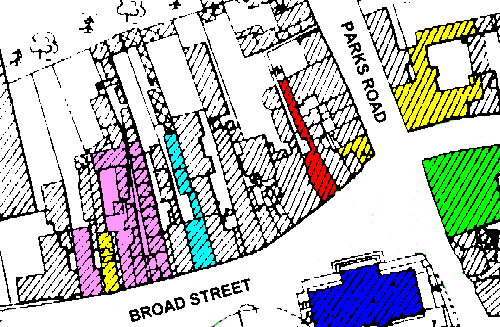
Firstly a word about the numbering in Broad Street. This ran from west to east along the south side of the street, starting from 1 at the junction with Cornmarket and ending with 34 at the Old Clarendon building. The north side was then numbered back from east to west, starting with number 35 at the corner of Parks Road. The houses which were demolished were numbers 35 to 47. I have not yet established when the numbers were introduced. However from a simple count of the number of houses, it is clear that some had been combined before 1898.
The dark-blue building is the Clarendon Building, originally the University Printing House, designed by Nicholas Hawksmoor and erected between 1712 and 1715. The delegates of the University Press still meet there, though the actual printing presses had been moved to Walton Street by 1830.
The buildings coloured in yellow are all Public Houses or Inns. The large inn at the extreme right of the plan on the corner of Parks Road and Holywell Street, is the King's Arms and is still in existence under that name today.
Opposite the Kings Arms and coloured green, is the Indian Institute building erected between 1883 and 1896 (and now occupied by the history faculty libraries). At https://www.oxfordhistory.org.uk/broad/buildings/east/old_indian_institute/index.html there is a web page devoted to the history of this building. In 1772 the corner appears to have been occupied by another inn, the "Coach and Horses", which closed sometime before 1810. This was replaced by Seal's Coffee House, which in turn was demolished when the Indian Institute was built.
There now follows a summary of Miriam Freeborn's description of some of the individual houses, concentrating chiefly upon their occupants between 1772 and 1930.
No. 35 Broad Street
The inn on the corner of Broad Street and Parks Road was called the "Dog and Partridge"
in 1772 and the landlord was also the owner, Richard DAVIS. The frontage was given as 17 feet
9 inches. At some time later, the Coach
and Horses on the opposite corner closed and the landlord moved across to No. 35, taking
his inn name with him. For a period around the 1810's it was known as the "Prince's Arms"
after the Prince Regent (1811-1820), later to become George IV. This name did not stick
and the name reverted to the "Coach and Horses" by which it was still known when the
building was finally demolished.
No. 36 Broad Street
In 1772 No.36 had a frontage of 14 feet, and was occupied by a Mr.CURTIS the apothecary:
he is recorded as having a son Thomas baptised at St.Mary Magdalene in 1748.
In the title deeds of 1744 the house is shown as the property of Mr.HAMPSHIRE of
Eynsham, and it passed 1813 to Mr.Henry WALSH, and later to Mrs. Hester CURTIS.
No. 37 Broad Street
No. 37 was two houses in 1772 separately occupied by a Mrs.JUDGE and a Mr.BADNALL. Their
frontages were 10 feet and 10 feet 6 inches respectively. The houses appear to have been
combined before 1796 when they are believed to have been the dwelling described as the
"Elephant" by Ann Freeborn.
No. 38 Broad Street
(This was the Freeborn house and is described in some detail by Miriam Freeborn.)
This house is marked in red on the plan.
In 1772, it was occupied by a Mr.PARKER who was warden at St.Mary Magdalene
in 1775: the frontage of the house is given as 18 feet 4 inches, and yet there
is mention of a passage at the side of the house giving access to a row of cottages
at the back, which are referred to by Ann FREEBORN in 1796. When it was rebuilt,
some time after the date of the survey, it is pretty evident that it was intended
to constitute two houses: every thing is duplicated, and the external appearance of the
house confirms this.
In 1794, the house was jointly purchased by Thomas DAVIS senior, Thomas DAVIS junior (a cook of the University) and Ann DAVIS, his sister from a Richard JOHNSON. Ann was by this time Mrs. FREEBORN, having married John FREEBORN in 1788. Ann had a son, John James Simms FREEBORN born in 1795. Tragically her husband died as a result of a fall from his horse in 1798. About a year later, Ann married Richard TREDWELL.
Miriam goes into some detail, concerning the complex finances involved in the joint ownership of the building, each of the parties at various times mortgaging part of their interest in the property. To add further complexity an adjacent piece of garden was purchased in 1796 (from its four joint owners!), a right of way was negotiated from the rear of the property through to Parks road and various cottages at the rear of the property were independently tenanted.
The following people were all involved in some way in these
transactions:
In 1796:
John BROWN (gent); James COSTAR; Emmanuel ROADS (grocer); Robert LANGFORD
(grocer, grandson and heir-at-law of Elizabeth LANGFORD deceased.
In 1808:
Mary MOUNTFORD (widow); Edward HUPERY; ? ROWSIER; ? ALDRIDGE; William THORPE (may
have occupied No. 39); Ebenezer SWAIN, John HOWES, Charles LENNARD & James SMITH (occupiers
of the row of cottages at the rear of No.38); Henry WALSH (neighbour to the north)
In 1820:
Thomas BAYLIS; Robert THONGER, saddler of Bicester; William TUBB (grocer);
Percival WALSH and John WALSH (brothers); Henry WALSH Esq. (probably their father, and a
neighbour of the Freeborns in 1832); William JOY & Thomas JOY (neighbours); John JOY
(probably their father); David RICKETTS (neighbour, possibly in Park Road).
No. 39, 40 & 41 Broad Street
In 1772 39 and 40 appear to have been a single house with a frontage of 24ft 6in,
occupied by Dr. HAYES Mus.Doc. It was later combined with No. 41 to form Acland
House. This combined property is shown to the left of No. 38 (red) on the plan.
In 1772, a Mr. DAVIS lived at No. 41. This may well have been Thomas DAVIS senior, father
of Ann DAVIS (later Ann FREEBORN then Ann TREADWELL), but this is not proven.
No. 42 Broad Street
In 1772 was a china shop, occupied by a Mrs. Grace PARSONS. It had a frontage of
18 feet 3 inches.
No. 43 Broad Street
In 1772 occupied by a Mr. BOLTON. It had a frontage of 22 feet 1 inches.
No. 44 Broad Street
In 1772 was owned by a Mr. THORP. It had a frontage of 21 feet 10 inches.
The survey indicates that in this case it was the owner
rather than the occupier who was to pay the tax. The occupier is not known.
No. 45 Broad Street
In 1772 occupied by a Mr. CURTISS. It is not known if he was related to the occupier
of No. 36. It had a frontage of 14 feet 1 inches.
No. 46 Broad Street
In 1772 occupied by a Mrs. JONES. It had a frontage of 21 feet 3 inches. Parts of this
property were amongst the oldest found in the demolished houses. It was described in detail
by Dr Pantin and it is the house whose plans have been reproduced in Oxford the
Buried City. It is identified in light-blue on the plan above.
No. 47 Broad Street
In 1772 occupied by a Dr. FOSTER. It had a frontage of 20 feet 4 inches. This was the last
of the houses which was demolished. Nos. 48 to 54 remain to this day.
No. 48, 49, 50 & 51 Broad Street
These houses are coloured violet on the plan.
In 1772 Nos. 48 & 49 were occupied by a Mr. FRANKLIN and had a combined frontage of
23 feet 6 inches. No. 50 was occupied (or owned?) by a Mr. CURTISS. Again it is not known
how he relates to the occupier(s) of Nos. 36 and 45, or indeed if they were all owned
by the same person and sub-let to un-named tenants. No. 50 had a frontage of 14 feet.
No. 51 was occupied by a Mr. HASKINS who was also taxed on the adjoining passage. This plus
the house had a combined frontage of 14 feet 3 inches. The four properties are today occupied
by Blackwells Bookshop and would have been so in the 1930's when the other houses were
demolished. (Photographs in Dr. Pantin's report in Oxonienia show the frontage of
Blackwells just as it appears today in 2001.) Benjamin Henry Blackwell opened his shop at
No. 50 in 1879. A photograph taken in the first decade of the 20th century shows Blackwells
occupying Nos. 50 & 51, with essentially the same front as today. No.49 seems to bear a
sign "Old Picture Shop" in this photograph. (This photograph is included in Oxford
in Old Photographs by Judi Caton (1988). Surprisingly Miriam Freeborn makes no reference
at all to Blackwells in her book. Presumably since the property was unaffected by the
demolition, she assumed its occupancy was "obvious" and required no mention.
No. 52 Broad Street
In 1772 was the "Duke of York" inn and was occupied by a Mrs. NORRIS. It had a frontage
of 13 feet 9 inches. Miriam Freeborn reports that in 1810, the lease of the "Duke of York"
was given to W. & J. Morrell by the Rev. Edward TURNER and his wife, for a term of 70 years.
She also reports that the inn is "now" (in 1943) called the "White Horse" and is "reputed to be
500 years old". The property is coloured yellow on the plan and is still the "White Horse"
in 2001.
No. 53 Broad Street
This is the last of the properties mentioned by Miriam Freeborn.
In 1772 is was occupied by a Mrs. SEELEY. It had a frontage of 23 feet 4 inches.
It too is now a part of Blackwell's Bookshop and is coloured violet on the plan.
Names mentioned in the above
There follows an alphabetical list of names of persons mentioned above, with approximate dates.
| Surname | Title / Christian Names | Date |
|---|---|---|
| ALDRIDGE | 1808 | |
| BADNELL | Mr. | 1772 |
| BAYLIS | Thomas | 1820 |
| BOLTON | Mr. | 1772 |
| BROWN | John (gent) | 1796 |
| COSTAR | James | 1796 |
| CURTIS | Mr. (apothecary) | 1772 |
| CURTIS | Thomas (son of above) | 1748- |
| CURTIS | Mrs. Hester | 1813+ |
| CURTISS | Mr. | 1772 |
| DAVIS | Mr. | 1772 |
| DAVIS | Thomas, senior (father of Ann) | 1772 |
| DAVIS | Thomas, junior (cook & brother of Ann) | 1772 |
| DAVIS | Ann, (married John FREEBORN & Richard TREDWELL) | 1765-1847 |
| DAVIS | Richard (Inn landlord) | 1772 |
| FOSTER | Dr. | 1772 |
| FRANKLIN | Mr. | 1772 |
| FREEBORN | Ann (see Ann DAVIS) | 1788 |
| FREEBORN | Emily Sarah | -1929 |
| FREEBORN | John | 1758-1798 |
| FREEBORN | John James Simms | 1795-1873 |
| FREEBORN | Miriam Elizabeth | 1943 |
| HAMPSHIRE | Mr. (of Eynsham) | 1744 |
| HASKINS | Mr. | 1772 |
| HAYES | Dr. Mus.Doc. | 1772 |
| HOWES | John | 1808 |
| HUPREY | Edward | 1808 |
| JOHNSON | Richard | 1794 |
| JONES | Mrs. | 1772 |
| JOY | John | 1820 |
| JOY | Thomas | 1820 |
| JOY | William | 1820 |
| JUDGE | Mrs. | 1772 |
| LANGFORD | Elizabeth (deceased) | 1796 |
| LANGFORD | Robert (grocer) | 1796 |
| LENNARD | Charles | 1808 |
| MOUNTFORD | Mary (widow) | 1808 |
| NORRIS | Mrs. | 1772 |
| PARKER | Mr. (warden St. Mary Mag.) | 1772, 1775 |
| PARSONS | Mrs. Grace (China Shop) | 1772 |
| RICKETTS | David | 1820 |
| ROADS | Emmanuel (grocer) | 1796 |
| ROWSIER | 1808 | |
| SEELEY | Mrs. | 1772 |
| SMITH | James | 1808 |
| SWAIN | Ebenezer | 1808 |
| THONGER | Robert (saddler of Bicester) | 1820 |
| THORP | Mr. | 1772 |
| THORP | Mr. | 1772 |
| THORP | William | 1808 |
| TREDWELL | Richard | 1799 |
| TREDWELL | Ann (see Ann DAVIS) | 1799 |
| TUBB | William (grocer) | 1820 |
| TURNER | Rev. Edward & his wife | 1810 |
| WALSH | Henry Esq. | 1808, 1813, 1820 |
| WALSH | John | 1820 |
| WALSH | Percival | 1820 |
The above represents the state of my knowledge of these people at the last update of this page. I am still working on this area so more will be added.
If you see any people you recognise, please send an email to Alan Simpson. I may well have more information about some of these people, than would fit here. I certainly have a much more extensive knowledge of the FREEBORN family.